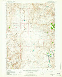
1961 Map of TTT Ranch
USGS Topo · Published 1964About this map
The TTT Ranch occupies a central position in this corner of Johnson County, situated where the South Fork Powder River joins the main course of the Powder River. Surveyed in the late 1950s and field-checked in 1961, the landscape reflects a ranching economy supported by complex water management, including the Tisdale Ditch and numerous reservoirs like King Res. The presence of scattered Claypits and a Drill Hole suggests early industrial interest in the area's mineral resources, while the network of unpaved routes such as Bear Lone Road and Arminto Road 10 Mi. provided essential connectivity for remote holdings.
Find a feature on this map
25 named features on this map. Tap any name to fly to it.
Don’t see what you’re looking for? This feature index may not catch every label — zoom into the map to look around manually.
Map Details
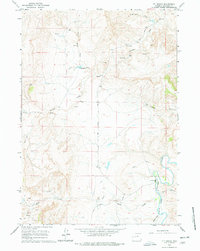
Editions of this 1961 TTT Ranch Map
3 editions found
Historical Maps of Johnson County Through Time
157 maps found

1900 Fort McKinney
Johnson County, WY

1903 Fort McKinney
Johnson County, WY

1953 Dry Fork Ranch
Johnson County, WY

1953 Fort Reno
Johnson County, WY

1953 Fort Reno SE
Johnson County, WY

1953 Hoe Ranch
Johnson County, WY

1953 The Nipple
Johnson County, WY

1954 House Creek
Johnson County, WY

1954 Linch
Johnson County, WY

1954 Taylor Ranch
Johnson County, WY

1961 Antelope Draw
Johnson County, WY

1961 Barnum
Johnson County, WY

1961 Dead Woman Crossing
Johnson County, WY

1961 Dry Creek Reservoir
Johnson County, WY

1961 Dugout Ranch
Johnson County, WY

1961 Elaine Draw
Johnson County, WY

1961 Figure 8 Reservoir
Johnson County, WY

1961 Fourmile Reservoir
Johnson County, WY

1961 Hibbard Draw
Johnson County, WY

1961 Kaycee NE
Johnson County, WY

1961 Provence Ranch
Johnson County, WY

1961 Schlicht Draw
Johnson County, WY

1961 Soldier Creek
Johnson County, WY

1961 Sussex
Johnson County, WY

1961 TTT Ranch
Johnson County, WY

1961 Wall Creek
Johnson County, WY

1963 Mayoworth
Johnson County, WY

1967 Beartrap Meadows
Johnson County, WY

1967 Caribou Creek
Johnson County, WY

1967 Cloud Peak
Johnson County, WY

1967 Gordon Creek
Johnson County, WY

1967 Hazelton
Johnson County, WY

1967 Hazelton Peak
Johnson County, WY

1967 Hunter Mesa
Johnson County, WY

1967 Klondike Ranch
Johnson County, WY

1967 Lake Angeline
Johnson County, WY

1967 Lake De Smet West
Johnson County, WY

1967 North Ridge
Johnson County, WY

1967 Powder River Pass
Johnson County, WY

1967 Robinson Canyon
Johnson County, WY

1967 Stone Mountain
Johnson County, WY

1967 Tabletop
Johnson County, WY

1967 Turk Springs
Johnson County, WY

1967 Willow Park Reservoir
Johnson County, WY

1970 Buffalo NE
Johnson County, WY

1970 Buffalo SE
Johnson County, WY

1970 Lake De Smet East
Johnson County, WY

1970 Purdy Reservoir
Johnson County, WY

1970 T A Ranch
Johnson County, WY

1970 Trabing
Johnson County, WY

1972 Bear Draw
Johnson County, WY

1972 Bowman Flat
Johnson County, WY

1972 Brown Ranch
Johnson County, WY

1972 Coyer Reservoir
Johnson County, WY

1972 Crazy Woman Ranch
Johnson County, WY

1972 Floate Draw
Johnson County, WY

1972 Fredrick Draw
Johnson County, WY

1972 Juniper Draw
Johnson County, WY

1972 Laskie Draw
Johnson County, WY

1972 Livingston Draw
Johnson County, WY

1972 Mitchell Draw
Johnson County, WY

1972 Negro Butte
Johnson County, WY

1972 Pine Gulch
Johnson County, WY

1972 Ploessers Draw
Johnson County, WY

1972 Somerville Flats East
Johnson County, WY

1972 Somerville Flats West
Johnson County, WY

1979 Mayoworth
Johnson County, WY

1979 Red Fork Powder River
Johnson County, WY

1981 Antelope Draw
Johnson County, WY

1984 Barnum
Johnson County, WY

1984 Fraker Mountain
Johnson County, WY

1984 Hole-in-the-wall
Johnson County, WY

1984 Packsaddle Canyon
Johnson County, WY

1984 Poker Butte
Johnson County, WY

1984 The Horn
Johnson County, WY

1993 Caribou Creek
Johnson County, WY

1993 Cloud Peak
Johnson County, WY

1993 Hazelton
Johnson County, WY

1993 Hazelton Peak
Johnson County, WY

1993 Hunter Mesa
Johnson County, WY

1993 Klondike Ranch
Johnson County, WY

1993 Lake Angeline
Johnson County, WY

1993 North Ridge
Johnson County, WY

1993 Powder River Pass
Johnson County, WY

1993 Stone Mountain
Johnson County, WY

1993 Willow Park Reservoir
Johnson County, WY

2021 Antelope Draw
Johnson County, WY

2021 Barnum
Johnson County, WY

2021 Bear Draw
Johnson County, WY

2021 Beartrap Meadows
Johnson County, WY

2021 Bowman Flat
Johnson County, WY

2021 Brown Ranch
Johnson County, WY

2021 Buffalo NE
Johnson County, WY

2021 Buffalo SE
Johnson County, WY

2021 Caribou Creek
Johnson County, WY

2021 Cloud Peak
Johnson County, WY

2021 Coyer Reservoir
Johnson County, WY

2021 Crazy Woman Ranch
Johnson County, WY

2021 Dead Woman Crossing
Johnson County, WY

2021 Dry Creek Reservoir
Johnson County, WY

2021 Dry Fork Ranch
Johnson County, WY

2021 Dugout Ranch
Johnson County, WY

2021 Elaine Draw
Johnson County, WY

2021 Figure 8 Reservoir
Johnson County, WY

2021 Floate Draw
Johnson County, WY

2021 Fort Reno
Johnson County, WY

2021 Fort Reno SE
Johnson County, WY

2021 Fourmile Reservoir
Johnson County, WY

2021 Fraker Mountain
Johnson County, WY

2021 Fredrick Draw
Johnson County, WY

2021 Gordon Creek
Johnson County, WY

2021 Hazelton
Johnson County, WY

2021 Hazelton Peak
Johnson County, WY

2021 Hibbard Draw
Johnson County, WY

2021 Hoe Ranch
Johnson County, WY

2021 Hole-in-the-Wall
Johnson County, WY

2021 House Creek
Johnson County, WY

2021 Hunter Mesa
Johnson County, WY

2021 Juniper Draw
Johnson County, WY

2021 Kaycee NE
Johnson County, WY

2021 Klondike Ranch
Johnson County, WY

2021 Lake Angeline
Johnson County, WY

2021 Lake De Smet East
Johnson County, WY

2021 Lake De Smet West
Johnson County, WY

2021 Laskie Draw
Johnson County, WY

2021 Linch
Johnson County, WY

2021 Livingston Draw
Johnson County, WY

2021 Mayoworth
Johnson County, WY

2021 Mitchell Draw
Johnson County, WY

2021 Negro Butte
Johnson County, WY

2021 North Ridge
Johnson County, WY

2021 Packsaddle Canyon
Johnson County, WY

2021 Pine Gulch
Johnson County, WY

2021 Ploessers Draw
Johnson County, WY

2021 Poker Butte
Johnson County, WY

2021 Powder River Pass
Johnson County, WY

2021 Provence Ranch
Johnson County, WY

2021 Purdy Reservoir
Johnson County, WY

2021 Red Fork Powder River
Johnson County, WY

2021 Robinson Canyon
Johnson County, WY

2021 Schlicht Draw
Johnson County, WY

2021 Soldier Creek
Johnson County, WY

2021 Somerville Flats East
Johnson County, WY

2021 Somerville Flats West
Johnson County, WY

2021 Stone Mountain
Johnson County, WY

2021 Sussex
Johnson County, WY

2021 Tabletop
Johnson County, WY

2021 T A Ranch
Johnson County, WY

2021 T A Ranch NE
Johnson County, WY

2021 Taylor Ranch
Johnson County, WY

2021 The Horn
Johnson County, WY

2021 The Nipple
Johnson County, WY

2021 Trabing
Johnson County, WY

2021 TTT Ranch
Johnson County, WY

2021 Turk Springs
Johnson County, WY

2021 Wall Creek
Johnson County, WY

2021 Willow Park Reservoir
Johnson County, WY