
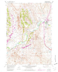
1961 Map of Kaycee
USGS Topo · Published 1965About this map
Kaycee serves as the focal point of this 1961 survey, situated at the confluence of the Powder River and its Middle Fork. The landscape is defined by an extensive network of family-held properties, including Gosney Ranch, Thompson Ranch, and Fancher Ranch, illustrating the deeply rooted cattle and ranching heritage of Johnson County. The topography is dominated by the dramatic Pine Ridge and the prominent Castle Rock to the south, while the complex hydrology of the region is managed through features like the Murphy Ditch, several dams, and a siphon system. The map also records the industrial presence of several gravel pits and a claypit near Bentonite Draw, highlighting the geological resources being extracted during this era. Traceable water management systems, from the Spratt Reservoir to the Kaycee Lagoon, show the mid-century infrastructure supporting this high plains community.
Find a feature on this map
44 named features on this map. Tap any name to fly to it.
Don’t see what you’re looking for? This feature index may not catch every label — zoom into the map to look around manually.
Map Details
Editions of this 1961 Kaycee Map
2 editions found
Other maps of this area

1955 · Arminto
USGS Topo · 1:250,000

1958 · Arminto
USGS Topo · 1:250,000

1961 · Barnum
USGS Topo · 1:62,500

1961 · Kaycee NE
USGS Topo · 1:24,000

1961 · Dry Creek Reservoir
USGS Topo · 1:24,000

1961 · TTT Ranch
USGS Topo · 1:24,000

1961 · Wall Creek
USGS Topo · 1:24,000

1961 · Hibbard Draw
USGS Topo · 1:24,000

1962 · Arminto
USGS Topo · 1:250,000

1963 · Mayoworth
USGS Topo · 1:62,500