
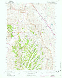
1961 Map of Wall Creek
USGS Topo · Published 1965About this map
The Powder River meanders through a landscape defined by industrial development and cattle ranching in the early 1960s. This Johnson County region shows a clear transition from the riparian corridors of the South Fork Powder River to the high-plains energy production of the North Tisdale Oil Field and East Tisdale Oil Field. The survey records several family-named landmarks and homesteads, such as the Snyder Ranch, Butts Ranch, and Linstead Place, providing a look at the rural land use of the era. The presence of numerous drill holes, oil wells, and an extensive network of pipelines and aqueducts underscores the importance of the local petroleum and water infrastructure. Distinctive natural features like Frewens Castle and the dramatic escarpment known as The Wall break the terrain, while early transit is marked by a winding Jeep Trail and the isolated Gaging Station near the river's edge.
Find a feature on this map
47 named features on this map. Tap any name to fly to it.
Don’t see what you’re looking for? This feature index may not catch every label — zoom into the map to look around manually.
Map Details
Editions of this 1961 Wall Creek Map
2 editions found
Other maps of this area

1955 · Arminto
USGS Topo · 1:250,000

1958 · Arminto
USGS Topo · 1:250,000

1961 · Kaycee NE
USGS Topo · 1:24,000

1961 · Figure 8 Reservoir
USGS Topo · 1:24,000

1961 · TTT Ranch
USGS Topo · 1:24,000

1961 · Dugout Ranch
USGS Topo · 1:24,000

1961 · Kaycee
USGS Topo · 1:24,000

1962 · Arminto
USGS Topo · 1:250,000

1968 · Salt Canyon
USGS Topo · 1:24,000
1968 · Broken Horn Creek
USGS Topo · 1:24,000