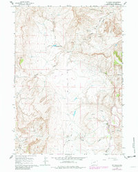
1961 Map of TTT Ranch
USGS Topo · Published 1982About this map
TTT Ranch and the surrounding ranching landscape of Johnson County are defined by a complex network of draws and creek beds that feed into the Powder River. This semi-arid terrain in the early 1960s shows a high degree of water management and industrial exploration, evidenced by the Tisdale Ditch irrigation system and scattered wells and drill holes. The confluence of the South Fork Powder River and Willow Creek serves as a focal point for the local geography, where a ford and a jeep trail indicate the limited but essential transport routes of the era. The presence of a Landing Strip and specialized features like a siphon reflect the practical adaptations required for large-scale livestock operations and resource extraction in this part of Wyoming, including several claypits located along Posey Creek.
Find a feature on this map
25 named features on this map. Tap any name to fly to it.
Don’t see what you’re looking for? This feature index may not catch every label — zoom into the map to look around manually.
Map Details
Editions of this 1961 TTT Ranch Map
3 editions found
Other maps of this area

1955 · Arminto
USGS Topo · 1:250,000

1958 · Arminto
USGS Topo · 1:250,000

1961 · Barnum
USGS Topo · 1:62,500

1961 · Kaycee NE
USGS Topo · 1:24,000

1961 · TTT Ranch
USGS Topo · 1:24,000

1961 · Wall Creek
USGS Topo · 1:24,000

1961 · Kaycee
USGS Topo · 1:24,000

1962 · Arminto
USGS Topo · 1:250,000

1968 · Willow Creek School
USGS Topo · 1:24,000

1968 · Salt Canyon
USGS Topo · 1:24,000