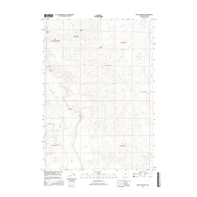
2015 Map of Hole-in-the-Wall
USGS Topo · Published 2015About this map
Hole-in-the-Wall serves as the central landmark for this section of Johnson County, a place defined by its distinct natural breaks and water sources. The landscape is a network of drainages and springs, including Taylor Spring, Shearing Pens Spring, and the West Prong Arminto Draw. These features, alongside named locations like Steamboat Rock and Poker Butte, suggest a territory long utilized for livestock and rangeland management. Sparse road access via Bar C Rd and Buffalo Creek Rd connects these remote points, while several small impoundments such as Keith Reservoir and Albert Number 2 Reservoir indicate the vital importance of water storage in this high-plains environment. The map details a complex topography where Rocky Draw and Peterson Draw feed into larger systems like Buffalo Cr, illustrating the erosional patterns of the Wyoming interior.
Find a feature on this map
27 named features on this map. Tap any name to fly to it.
Don’t see what you’re looking for? This feature index may not catch every label — zoom into the map to look around manually.
Map Details
Editions of this 2015 Hole-in-the-Wall Map
This is the sole edition of this map. No revisions or reprints were ever made.
Other maps of this area

1955 · Arminto
USGS Topo · 1:250,000

1958 · Arminto
USGS Topo · 1:250,000

1961 · Barnum
USGS Topo · 1:62,500

1961 · TTT Ranch
USGS Topo · 1:24,000

1961 · Kaycee
USGS Topo · 1:24,000

1962 · Arminto
USGS Topo · 1:250,000

1968 · Willow Creek School
USGS Topo · 1:24,000

1968 · Roughlock Hill
USGS Topo · 1:24,000
1968 · Broken Horn Creek
USGS Topo · 1:24,000
1979 · Red Fork Powder River
USGS Topo · 1:24,000