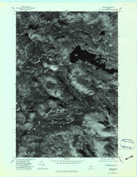
1977 Map of Holeb
USGS Topo · Published 1983About this map
Holeb serves as the primary focal point of this orthophotoquad, situated along the sinuous path of the Moose River in Somerset County. Unlike a traditional topographic map, this photographic record from imagery taken in late 1977 reveals the actual density of forest cover and the precise shoreline of Holeb Pond. The terrain is dominated by the prominence of Attean Mountain to the southeast, while a network of drainage systems including Turner Brook, Mc Kenney Brook, and Barrett Brook feed into the central river valley. The settlement at Holeb appears as a distinct cleared area within the surrounding timberland, providing a clear visual record of human activity and land management in this Maine woods region during the late 1970s.
Find a feature on this map
7 named features on this map. Tap any name to fly to it.
Don’t see what you’re looking for? This feature index may not catch every label — zoom into the map to look around manually.
Map Details
Editions of this 1977 Holeb Map
This is the sole edition of this map. No revisions or reprints were ever made.
Other maps of this area

1923 · Attean
USGS Topo · 1:62,500

1925 · Attean
USGS Topo · 1:62,500

1928 · Chain Lakes
USGS Topo · 1:48,000

1928 · Skinner
USGS Topo · 1:48,000

1928 · Spencer
USGS Topo · 1:48,000

1931 · Skinner
USGS Topo · 1:62,500

1932 · Spencer
USGS Topo · 1:62,500

1932 · Chain Lakes
USGS Topo · 1:62,500

1935 · Chain Lakes
USGS Topo · 1:62,500

1949 · Jackman
USGS Topo · 1:250,000
Featured Places
- Dennistown Plantation, ME
- Attean Township, ME
- Rayton Township, ME
- Appleton Township, ME
- Forsyth Township, ME