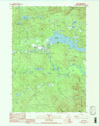
1989 Map of Holeb
USGS Topo · Published 1989About this map
Holeb stands as a focal point in this remote pocket of Somerset County, where the Canadian Pacific railroad parallels the winding path of the Moose River. The landscape is dominated by a complex network of waterways and wetlands, from the expansive Holeb Pond with its prominent Birch Island to the isolated reaches of Big Fish Pond and Barrett Pond. The topography is defined by significant elevations such as Attean Mountain and Burnt Jacket Mountain, which overlook a territory marked by traditional land divisions like Dennistown Plt and Forsyth. This late-twentieth-century survey reveals a wilderness managed for timber and recreation, anchored by the Boston Ranch settlement. The transition from the rapid waters at Camel Rips to the still surfaces of Long Pond and Mc Kenney Pond illustrates the diverse hydrological character of the Maine woods before the turn of the millennium.
Find a feature on this map
31 named features on this map. Tap any name to fly to it.
Don’t see what you’re looking for? This feature index may not catch every label — zoom into the map to look around manually.
Map Details
Editions of this 1989 Holeb Map
This is the sole edition of this map. No revisions or reprints were ever made.
Other maps of this area

1923 · Attean
USGS Topo · 1:62,500

1925 · Attean
USGS Topo · 1:62,500

1928 · Chain Lakes
USGS Topo · 1:48,000

1928 · Skinner
USGS Topo · 1:48,000

1928 · Spencer
USGS Topo · 1:48,000

1931 · Skinner
USGS Topo · 1:62,500

1932 · Spencer
USGS Topo · 1:62,500

1932 · Chain Lakes
USGS Topo · 1:62,500

1935 · Chain Lakes
USGS Topo · 1:62,500

1949 · Jackman
USGS Topo · 1:250,000
Featured Places
- Dennistown Plantation, ME
- Attean Township, ME
- Rayton Township, ME
- Appleton Township, ME
- Forsyth Township, ME