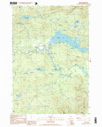
1997 Map of Holeb
USGS Topo · Published 1999About this map
Holeb Pond and the winding course of the Moose River dominate this Somerset County landscape during the late twentieth century. This area is characterized by a network of water bodies and timberlands, with small outpost settlements like Holeb and Boston Ranch serving as focal points for local activity. The presence of a Gravel Pit and numerous private roads suggests an economy tied to resource extraction and land management typical of the Maine North Woods.
Find a feature on this map
39 named features on this map. Tap any name to fly to it.
Don’t see what you’re looking for? This feature index may not catch every label — zoom into the map to look around manually.
Map Details
Editions of this 1997 Holeb Map
This is the sole edition of this map. No revisions or reprints were ever made.
Other maps of this area

1923 · Attean
USGS Topo · 1:62,500

1925 · Attean
USGS Topo · 1:62,500

1928 · Chain Lakes
USGS Topo · 1:48,000

1928 · Skinner
USGS Topo · 1:48,000

1928 · Spencer
USGS Topo · 1:48,000

1931 · Skinner
USGS Topo · 1:62,500

1932 · Spencer
USGS Topo · 1:62,500

1932 · Chain Lakes
USGS Topo · 1:62,500

1935 · Chain Lakes
USGS Topo · 1:62,500

1949 · Jackman
USGS Topo · 1:250,000
Featured Places
- Dennistown Plantation, ME
- Attean Township, ME
- Rayton Township, ME
- Appleton Township, ME
- Forsyth Township, ME