1982 Map of Holland
USGS Topo · Published 1982About this map
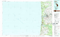
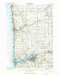
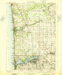
Lake Michigan's eastern shoreline anchors this 1982 survey, revealing the established coastal communities and agricultural interior of Ottawa and Allegan counties. The city of Holland is the primary hub, surrounded by smaller settlements like Zeeland, Noordeloos, and West Olive. The map illustrates a landscape transitioning from the recreational shores of Holland State Park and Saugatuck Dunes State Park to the managed wilderness of the Allegan State Game Area further south. Transportation is defined by the Chesapeake and Ohio railroad and the Blue Star Memorial Highway, which parallel the coast. Significant maritime and aviation landmarks, including Lake Macatawa, Mt Baldhead, and Tulip City Airport, emphasize the region's role as a center for travel and commerce. Numerous drains and creeks, such as Worley Drain and Pigeon Creek, reveal the intensive drainage efforts that support the local farming economy.
Find a feature on this map
61 named features on this map. Tap any name to fly to it.
Don’t see what you’re looking for? This feature index may not catch every label — zoom into the map to look around manually.
Map Details
Editions of this 1982 Holland Map
This is the sole edition of this map. No revisions or reprints were ever made.
Historical Maps of Holland Through Time
Featured Locations
- Holland, MI
- Zeeland, MI
- Port Sheldon, Port Sheldon Township
- Overisel, Overisel Township
- Fillmore, Fillmore Township