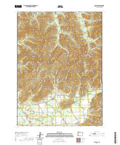
2020 Map of Holland
USGS Topo · Published 2020About this map
Holland and Bridgeview anchor the southern portion of this Josephine County landscape, situated where the East Fork Illinois River and its tributaries emerge from the surrounding heights. The map reveals a complex network of forest and resource roads, including McMullin Creek Rd and Kelly Creek Rd, which provide access to the drainages and gulches that define the local topography. Notable terrain features like Lime Rock and Green Gulch rise above the valleys, while water sources such as Horse Spring and Brown Slough dot the lower elevations. The presence of the B Bar Ranch Airport suggests the continued importance of private aviation in managing these expansive tracts of land. Genealogists and historians can trace the paths of numerous creeks like Thompson Creek and Sucker Creek, which have long shaped the settlement patterns and agricultural development of this corner of Oregon.
Find a feature on this map
81 named features on this map. Tap any name to fly to it.
Don’t see what you’re looking for? This feature index may not catch every label — zoom into the map to look around manually.
Map Details
Editions of this 2020 Holland Map
This is the sole edition of this map. No revisions or reprints were ever made.
Other maps of this area

1908 · Grants Pass
USGS Topo · 1:125,000

1917 · Kerby
USGS Topo · 1:125,000

1918 · Kerby
USGS Topo · 1:125,000

1945 · Kerby
USGS Topo · 1:125,000

1954 · Cave Junction
USGS Topo · 1:62,500

1954 · Oregon Caves
USGS Topo · 1:62,500

1954 · Selma
USGS Topo · 1:62,500

1954 · Grants Pass
USGS Topo · 1:62,500

1955 · Medford
USGS Topo · 1:250,000

1957 · Medford
USGS Topo · 1:250,000