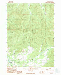
1989 Map of Holland
USGS Topo · Published 1989About this map
Fort Briggs (Historical Site) anchors the southwestern corner of this survey, marking a significant point of interest near the confluence of the Illinois River and Althouse Cr. The landscape transitions from the broad agricultural flats of the Illinois Valley into a dense network of drainages and ridges. Small settlements like Holland and Bridgeview are situated along the valley floor, connected by a network of rural roads that follow the path of Sucker Creek. The topography is defined by prominent landmarks such as Lime Rock and numerous named tributaries, including McMullin Creek and Thompson Creek, which carve through the northern elevations. This map illustrates the late-twentieth-century rural character of the region, where the flat valley lands meet the steep, timbered slopes of Josephine County.
Find a feature on this map
21 named features on this map. Tap any name to fly to it.
Don’t see what you’re looking for? This feature index may not catch every label — zoom into the map to look around manually.
Map Details
Editions of this 1989 Holland Map
This is the sole edition of this map. No revisions or reprints were ever made.
Other maps of this area

1908 · Grants Pass
USGS Topo · 1:125,000

1917 · Kerby
USGS Topo · 1:125,000

1918 · Kerby
USGS Topo · 1:125,000

1945 · Kerby
USGS Topo · 1:125,000

1954 · Cave Junction
USGS Topo · 1:62,500

1954 · Oregon Caves
USGS Topo · 1:62,500

1954 · Selma
USGS Topo · 1:62,500

1954 · Grants Pass
USGS Topo · 1:62,500

1955 · Medford
USGS Topo · 1:250,000

1957 · Medford
USGS Topo · 1:250,000