2023 Map of Holley
USGS Topo · Published 2023About this map
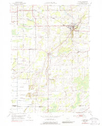
The Erie Canal cuts through the northeastern corner of this landscape, defining the industrial and transit history of Holley. This 2023 survey reveals a rural landscape deeply marked by its family and community heritage, visible in a dense network of interment sites like Hillside Cem, Maplewood Cem, and the Robinson Burial Ground. Agriculture and local industry persist in the landscape through features such as Keelers Gravel Pit and the fertile areas around Manning Muckland Creek. Smaller settlements like Fancher, Manning, and Bennetts Corners are connected by a grid of county roads that cross the East Branch Sandy Creek. The southern reaches of the map are defined by the transition from Orleans Co into Genesee County, near the rise of Honest Hill.
Find a feature on this map
79 named features on this map. Tap any name to fly to it.
Don’t see what you’re looking for? This feature index may not catch every label — zoom into the map to look around manually.
Map Details
Editions of this 2023 Holley Map
This is the sole edition of this map. No revisions or reprints were ever made.