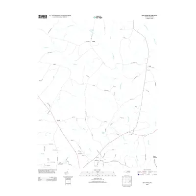
2013 Map of Hollister
USGS Topo · Published 2013About this map
Hollister and the surrounding Warren County countryside reflect a rural landscape shaped by the headwaters of the Fishing Creek system. This area, anchored by settlements like Old Bethlehem and Arcola, maintains a traditional pattern of small communities connected by a network of state routes and local roads such as Pullen Rd and Tabron School Rd. The hydrology of the region is prominent, with Little Fishing Cr and Porter Cr carving through the terrain, while landmarks like Ryder's Pond and Quails Pond indicate a history of local water management. To the southeast, the terrain transitions into the protected landscape of Medoc Mountain State Park, featuring the distinct elevation of Medoc Mountain itself. The map captures a moment of modern continuity in North Carolina's coastal plain, where geographic features like Bear Swamp and Bobs Br remain central to the local character.
Find a feature on this map
83 named features on this map. Tap any name to fly to it.
Don’t see what you’re looking for? This feature index may not catch every label — zoom into the map to look around manually.
Map Details
Editions of this 2013 Hollister Map
This is the sole edition of this map. No revisions or reprints were ever made.
Other maps of this area

1953 · Norfolk
USGS Topo · 1:250,000

1953 · Greensboro
USGS Topo · 1:250,000

1954 · Greensboro
USGS Topo · 1:250,000

1962 · Greensboro
USGS Topo · 1:250,000

1963 · Ringwood
USGS Topo · 1:24,000

1963 · Essex
USGS Topo · 1:24,000

1966 · Greensboro
USGS Topo · 1:250,000
1970 · Macon
USGS Topo · 1:24,000

1971 · Inez
USGS Topo · 1:24,000

1973 · Aurelian Springs
USGS Topo · 1:24,000