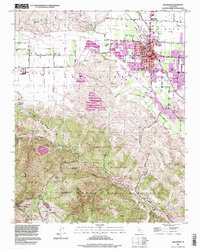
1995 Map of Hollister
USGS Topo · Published 1998About this map
The city of Hollister dominates this mid-1990s landscape, serving as a hub where the intensive agriculture of the San Juan Valley meets the rising elevations of the Gabilan Range. A significant geological feature, the San Andreas Rift Zone, cuts diagonally across the terrain, shaping the narrow canyons and ridges south of the city. This survey captures a moment of local growth, with developments such as Sunnyslope School and the Hazel Hawkins Hospital appearing alongside the established street grid and the IOOF Cem.
Find a feature on this map
47 named features on this map. Tap any name to fly to it.
Don’t see what you’re looking for? This feature index may not catch every label — zoom into the map to look around manually.
Map Details
Editions of this 1995 Hollister Map
This is the sole edition of this map. No revisions or reprints were ever made.
Other maps of this area

1910 · Salinas
USGS Topo · 1:31,680

1912 · Salinas
USGS Topo · 1:62,500

1915 · San Juan Bautista
USGS Topo · 1:48,000

1917 · San Juan Bautista
USGS Topo · 1:62,500

1919 · Hollister
USGS Topo · 1:48,000

1921 · Gonzales
USGS Topo · 1:62,500

1921 · Hollister
USGS Topo · 1:62,500

1923 · Hollister
USGS Topo · 1:62,500

1939 · San Juan Bautista
USGS Topo · 1:62,500

1940 · San Juan Bautista
USGS Topo · 1:62,500