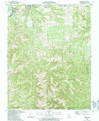
1989 Map of Hollister
USGS Topo · Published 1989About this map
Lake Taneycomo and the rugged Ozark Plateau terrain define this late 20th-century landscape on the Missouri-Arkansas border. This map captures a region in transition, balancing the established community of Hollister and the academic grounds of The School of the Ozarks at Point Lookout with the remote expanses of the Mincy State Wildlife Area. The industrial and transport infrastructure of Taney County is evident through the Missouri Pacific rail line and Clark Airport, while the rural character is maintained by numerous named hollows like Coalpit Hollow and Happy Hollow. Genealogists will find value in the scattered country churches and burial grounds, such as the Vanzandt Cem and Ridgedale Ch, which mark the small settlements of Melva, Ridgedale, and Kirbyville as they appeared before the further modern development of the Branson area.
Find a feature on this map
32 named features on this map. Tap any name to fly to it.
Don’t see what you’re looking for? This feature index may not catch every label — zoom into the map to look around manually.
Map Details
Editions of this 1989 Hollister Map
This is the sole edition of this map. No revisions or reprints were ever made.
Other maps of this area

1904 · Harrison
USGS Topo · 1:125,000

1905 · Harrison
USGS Topo · 1:125,000

1907 · Forsyth
USGS Topo · 1:125,000

1945 · Harrison
USGS Topo · 1:250,000

1949 · Harrison
USGS Topo · 1:250,000

1950 · Garber
USGS Topo · 1:24,000

1954 · Harrison
USGS Topo · 1:250,000

1956 · Table Rock Dam
USGS Topo · 1:24,000

1956 · Garber
USGS Topo · 1:24,000
1956 · Mincy
USGS Topo · 1:24,000