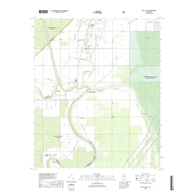
2018 Map of Holly Bluff
USGS Topo · Published 2018About this map
Holly Bluff and Campbellville serve as central hubs in this landscape where the Big Sunflower River and Fifteenmile Bayou wind through the alluvial plain. The area is defined by its agricultural character and extensive conservation lands, including parts of the Delta National Forest and the Panther Swamp National Wildlife Refuge. A network of levee roads, such as W Levee Rd, highlights the region's managed hydrology, which is further emphasized by the Will M. Whittington Auxiliary Channel. Local history and genealogy are anchored by numerous family and community burial sites, including Tanglewood Cem, Kettleman Cem, and Jeffery Cem. Small settlements like George, Patmos, and Spanish Fort dot the map, connected by rural routes like Holly Bluff Gin Rd and Satartia Rd, tracing the residential patterns of the western Mississippi Delta.
Find a feature on this map
51 named features on this map. Tap any name to fly to it.
Don’t see what you’re looking for? This feature index may not catch every label — zoom into the map to look around manually.
Map Details
Editions of this 2018 Holly Bluff Map
This is the sole edition of this map. No revisions or reprints were ever made.
Other maps of this area

1939 · Onward
USGS Topo · 1:62,500

1939 · Lorenzen
USGS Topo · 1:62,500

1940 · Mechanicsburg
USGS Topo · 1:62,500

1955 · Jackson
USGS Topo · 1:250,000

1961 · Jackson
USGS Topo · 1:250,000

1961 · Bayland
USGS Topo · 1:62,500

1962 · Jackson
USGS Topo · 1:250,000

1963 · Mechanicsburg
USGS Topo · 1:62,500

1963 · Onward
USGS Topo · 1:62,500

1964 · Lorenzen
USGS Topo · 1:62,500