
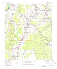
1964 Map of Lorenzen
USGS Topo · Published 1966About this map
Deer Creek and the Illinois Central RR anchor the Mississippi Delta landscape of Sharkey County on this mid-1960s survey. The map details a complex network of bayous and wetlands, including the Sunflower Waterfowl Project and the winding course of the Little Sunflower River. Agricultural and social life is evidenced by the high density of rural churches and community cemeteries, such as St Michaels Ch, Guiding Star Ch, and the Elmwood Cem.
Find a feature on this map
83 named features on this map. Tap any name to fly to it.
Don’t see what you’re looking for? This feature index may not catch every label — zoom into the map to look around manually.
Map Details
Editions of this 1964 Lorenzen Map
2 editions found
Other maps of this area

1909 · Wilsons Point
USGS Topo · 1:24,000

1913 · Wilson Point
USGS Topo · 1:31,680

1939 · Onward
USGS Topo · 1:62,500

1939 · Lorenzen
USGS Topo · 1:62,500

1939 · Readland
USGS Topo · 1:62,500

1939 · Alsatia
USGS Topo · 1:62,500

1939 · Mayersville
USGS Topo · 1:62,500

1939 · Swan Lake
USGS Topo · 1:62,500

1940 · Auter
USGS Topo · 1:62,500

1940 · Mechanicsburg
USGS Topo · 1:62,500