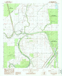
1988 Map of Holly Bluff
USGS Topo · Published 1988About this map
The Big Sunflower River defines the landscape of the Yazoo-Mississippi Delta in this late-1980s survey, where the winding waterway separates Sharkey and Yazoo counties. The settlement of Holly Bluff sits at a prominent bend in the river, serving as a focal point near the Holly Bluff Cut-Off. This area is characterized by vast conservation lands, including the Delta National Forest to the west and the Panther Swamp National Wildlife Refuge to the east, illustrating the region's commitment to preserving the bottomland hardwood ecosystem.
Find a feature on this map
33 named features on this map. Tap any name to fly to it.
Don’t see what you’re looking for? This feature index may not catch every label — zoom into the map to look around manually.
Map Details
Editions of this 1988 Holly Bluff Map
This is the sole edition of this map. No revisions or reprints were ever made.
Other maps of this area

1939 · Onward
USGS Topo · 1:62,500

1939 · Lorenzen
USGS Topo · 1:62,500

1940 · Mechanicsburg
USGS Topo · 1:62,500

1955 · Jackson
USGS Topo · 1:250,000

1961 · Jackson
USGS Topo · 1:250,000

1961 · Bayland
USGS Topo · 1:62,500

1962 · Jackson
USGS Topo · 1:250,000

1963 · Mechanicsburg
USGS Topo · 1:62,500

1963 · Onward
USGS Topo · 1:62,500

1964 · Lorenzen
USGS Topo · 1:62,500