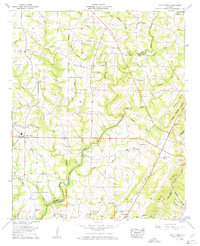
1958 Map of Holly Pond
USGS Topo · Published 1960About this map
The Black Warrior River Mulberry Fork meanders through the landscape where Cullman and Blount Counties meet, defining the region's topography during the late 1950s. The town of Holly Pond serves as a central hub, surrounded by a dense network of country churches such as Turkey Hop Ch, Zion Grove Ch, and Pleasant View Ch. These sites, along with numerous family-oriented burial grounds like Sheppard Cem and Pine Grove Cem, indicate a deeply rooted rural community structure.
Find a feature on this map
61 named features on this map. Tap any name to fly to it.
Don’t see what you’re looking for? This feature index may not catch every label — zoom into the map to look around manually.
Map Details
Editions of this 1958 Holly Pond Map
3 editions found
Other maps of this area

1885 · Gadsden
USGS Topo · 1:125,000

1888 · Cullman
USGS Topo · 1:125,000

1888 · Gadsden
USGS Topo · 1:125,000

1892 · Cullman
USGS Topo · 1:125,000

1892 · Gadsden
USGS Topo · 1:125,000

1895 · Gadsden
USGS Topo · 1:125,000

1903 · Gadsden
USGS Topo · 1:125,000

1936 · Hulaco
USGS Topo · 1:24,000

1936 · Arab
USGS Topo · 1:24,000

1936 · Lawrence Cove
USGS Topo · 1:24,000