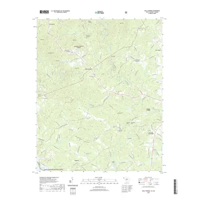
2020 Map of Holly Springs
USGS Topo · Published 2020About this map
Holly Springs serves as the central hub for this corner of Oconee County, situated where the Chauga River divides the landscape. The region is defined by its deep spiritual and community roots, evidenced by numerous local congregations including the Rocky Fork Baptist Church and Rider Mountain Holiness Church. To the south, Madison sits near the northern reaches of Hartwell Lake, while the upper elevations are marked by distinctive peaks like Rockhouse Mtn and Piney Mtn. The map documents a network of family-named landmarks and resting places, such as Stewart Cem and Duke Cem, which reflect the generations of residents who have lived along the Toxaway Cr drainage. This 2020 edition provides a clear view of the intersection of private homesteads and public lands within the Sumter National Forest and Chattahoochee National Forest.
Find a feature on this map
123 named features on this map. Tap any name to fly to it.
Don’t see what you’re looking for? This feature index may not catch every label — zoom into the map to look around manually.
Map Details
Editions of this 2020 Holly Springs Map
This is the sole edition of this map. No revisions or reprints were ever made.
Other maps of this area

1886 · Walhalla
USGS Topo · 1:125,000

1892 · Walhalla
USGS Topo · 1:125,000

1896 · Walhalla
USGS Topo · 1:125,000

1954 · Greenville
USGS Topo · 1:250,000

1957 · Tugaloo Lake
USGS Topo · 1:24,000
1957 · Rainy Mountain
USGS Topo · 1:24,000

1958 · Greenville
USGS Topo · 1:250,000
1959 · Walhalla
USGS Topo · 1:24,000
1961 · Whetstone
USGS Topo · 1:24,000
1963 · Westminster
USGS Topo · 1:24,000