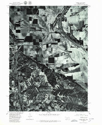
1977 Map of Homer
USGS Topo · Published 1979About this map
Homer, Nebraska, sits at the intersection of the rugged loess bluffs and the expansive floodplains of the Missouri River valley. Published by the U.S. Geological Survey in cooperation with the Bureau of Indian Affairs, this 1970s orthophotograph provides a clear visual of the landscape as it was captured in May 1977. The imagery reveals the complex relationship between the undulating wooded hills and the highly organized, geometric agricultural fields of the lowlands. The winding path of the Missouri River dominates the eastern edge of the quadrangle, while the engineered channel of the Omaha Creek Ditch and the natural course of Omaha Creek illustrate the historical efforts to manage drainage and protect the fertile valley floor for farming.
Find a feature on this map
4 named features on this map. Tap any name to fly to it.
Don’t see what you’re looking for? This feature index may not catch every label — zoom into the map to look around manually.
Map Details
Editions of this 1977 Homer Map
This is the sole edition of this map. No revisions or reprints were ever made.
Other maps of this area

1955 · Sioux City
USGS Topo · 1:250,000

1958 · Sioux City
USGS Topo · 1:250,000

1959 · Sioux City
USGS Topo · 1:250,000

1963 · Sioux City South
USGS Topo · 1:24,000

1964 · Sergeant Bluff
USGS Topo · 1:24,000

1964 · Homer
USGS Topo · 1:24,000

1964 · Salix
USGS Topo · 1:24,000

1966 · Walthill
USGS Topo · 1:24,000

1966 · Pender NE
USGS Topo · 1:24,000
1967 · Jackson
USGS Topo · 1:24,000