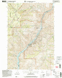
2004 Map of Homestead
USGS Topo · Published 2007About this map
The Snake River carves a deep path through this borderland where the Wallowa-Whitman National Forest meets the Payette National Forest. This 2004 revision reveals a landscape dominated by the Hells Canyon Reservoir, emphasizing the dramatic relief between the river floor and high points like Windy Ridge. The map documents a history of resource extraction, noting numerous prospects, a Mine Shaft, and the Irondyke Mine near the riverbank.
Find a feature on this map
53 named features on this map. Tap any name to fly to it.
Don’t see what you’re looking for? This feature index may not catch every label — zoom into the map to look around manually.
Map Details
Editions of this 2004 Homestead Map
2 editions found
Other maps of this area

1920 · Seven Devils Mining District
USGS Topo · 1:48,000

1955 · Baker
USGS Topo · 1:250,000

1955 · Grangeville
USGS Topo · 1:250,000

1957 · Cuprum
USGS Topo · 1:62,500

1957 · Homestead
USGS Topo · 1:62,500

1957 · Copperfield
USGS Topo · 1:62,500

1957 · Hornet
USGS Topo · 1:62,500

1959 · Baker
USGS Topo · 1:250,000

1959 · Grangeville
USGS Topo · 1:250,000

1980 · McCall
USGS Topo · 1:100,000