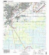
1994 Map of Homestead
USGS Topo · Published 1999About this map
Homestead and the surrounding agricultural and residential developments of southern Miami-Dade County appear in detail as they were following the mid-1990s. The landscape is defined by the strict geometry of the Homestead Corporate Boundary and the extensive network of drainage infrastructure, including the North Canal, Florida City Canal, and Mowry Canal No C103. These waterways allowed for the expansion of settlements like Leisure City and Modello alongside more established sites like Florida City.
Find a feature on this map
33 named features on this map. Tap any name to fly to it.
Don’t see what you’re looking for? This feature index may not catch every label — zoom into the map to look around manually.
Map Details
Editions of this 1994 Homestead Map
This is the sole edition of this map. No revisions or reprints were ever made.
Other maps of this area

1949 · Card Sound
USGS Topo · 1:24,000

1949 · Arsenicker Keys
USGS Topo · 1:24,000

1949 · Goulds
USGS Topo · 1:24,000

1949 · Perrine
USGS Topo · 1:24,000

1950 · Homestead
USGS Topo · 1:24,000

1950 · Glades
USGS Topo · 1:24,000

1956 · Goulds
USGS Topo · 1:24,000

1956 · Card Sound
USGS Topo · 1:24,000

1956 · Perrine
USGS Topo · 1:24,000

1956 · Grossman Hammock
USGS Topo · 1:24,000