
1943 Map of Honesdale
USGS Topo · Published 1943About this map
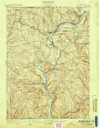
The Erie RR follows the winding path of the Upper Delaware River during the Second World War, anchoring a landscape defined by small valley settlements and high-altitude mountain schools. Industrial activity is concentrated at Cadosia Factories and the rail hub of Hancock, while the surrounding terrain in Wayne and Delaware counties is dotted with community centers like Pleasant Mount and Herrick Center. This military-compiled survey provides a clear view of the mid-century infrastructure in the northern Poconos, including the Honesdale Airport and a dense network of rural educational sites such as High Lake School and Pine Mill School. Numerous small water bodies like Starlight Lake Church and Belmont Lake are situated between the river valleys and the ridges of Mount Ararat, reflecting a region where local geography dictated the placement of early 20th-century churches and post offices like Peakville P O.
Find a feature on this map
275 named features on this map. Tap any name to fly to it.
Don’t see what you’re looking for? This feature index may not catch every label — zoom into the map to look around manually.
Map Details
Editions of this 1943 Honesdale Map
This is the sole edition of this map. No revisions or reprints were ever made.
Other maps of this area

1889 · Scranton
USGS Topo · 1:62,500

1891 · Scranton
USGS Topo · 1:62,500

1892 · Honesdale
USGS Topo · 1:62,500

1892 · Dundaff
USGS Topo · 1:62,500

1893 · Scranton
USGS Topo · 1:62,500
1905 · Nineveh
USGS Topo · 1:62,500

1913 · Milford
USGS Topo · 1:62,500

1915 · Milford
USGS Topo · 1:62,500

1920 · Long Eddy
USGS Topo · 1:62,500

1920 · Damascus
USGS Topo · 1:62,500