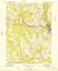
1949 Map of Honesdale
USGS Topo · Published 1949About this map
Honesdale serves as the focal point of this Wayne County landscape, situated at the confluence of Dyberry Creek and the West Branch Lackawaxen River. The era's transportation network is clearly defined by the Erie RR and the Roosevelt Highway, which follow the river valleys through settlements like Seelyville and Prompton. This survey details a transition from the industrial activity at the Glass Factory near the north border to the agricultural and civic centers like the County Fairgrounds. The map is particularly rich for genealogical research, documenting numerous rural institutions including St Patricks Ch, Rickard Sch, and various family-named landmarks like Coggins Corner and Steene. Numerous ponds and reservoirs, such as Cadjaw Pond and Reining Pond, dot the uplands between the townships of Texas and Cherry Ridge, reflecting the region's managed water resources during the late 1940s.
Find a feature on this map
52 named features on this map. Tap any name to fly to it.
Don’t see what you’re looking for? This feature index may not catch every label — zoom into the map to look around manually.
Map Details
Editions of this 1949 Honesdale Map
This is the sole edition of this map. No revisions or reprints were ever made.
Other maps of this area

1892 · Honesdale
USGS Topo · 1:62,500

1920 · Damascus
USGS Topo · 1:62,500

1923 · Damascus
USGS Topo · 1:62,500

1928 · Ariel
USGS Topo · 1:62,500

1932 · Ariel
USGS Topo · 1:62,500

1935 · Hawley
USGS Topo · 1:62,500

1938 · Hawley
USGS Topo · 1:62,500

1943 · Honesdale
USGS Topo · 1:125,000

1944 · Damascus
USGS Topo · 1:62,500

1946 · Forest City
USGS Topo · 1:24,000