
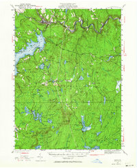
1935 Map of Hawley
USGS Topo · Published 1955About this map
Lake Wallenpaupack and the rugged topography of the Pocono Mountains define this mid-1930s landscape across the border of Wayne and Pike Counties. The shoreline of the large reservoir serves as a central hub for surrounding settlements like Tafton and Paupack, while the northern edge of the map follows the winding path of the Lackawaxen River and the Erie railroad. Here, rail infrastructure is evident at Shimmers Rock Cut and small stops like Kimble and Glen Eyre.
Find a feature on this map
92 named features on this map. Tap any name to fly to it.
Don’t see what you’re looking for? This feature index may not catch every label — zoom into the map to look around manually.
Map Details
Editions of this 1935 Hawley Map
2 editions found
Other maps of this area

1891 · Wallpack
USGS Topo · 1:62,500

1892 · Honesdale
USGS Topo · 1:62,500

1893 · Wallpack
USGS Topo · 1:62,500

1913 · Milford
USGS Topo · 1:62,500

1915 · Milford
USGS Topo · 1:62,500

1919 · Pocono
USGS Topo · 1:62,500

1920 · Damascus
USGS Topo · 1:62,500

1921 · Pocono
USGS Topo · 1:62,500

1922 · White Lake
USGS Topo · 1:62,500

1923 · Damascus
USGS Topo · 1:62,500