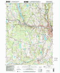
1999 Map of Honesdale
USGS Topo · Published 2002About this map
Honesdale and its surrounding townships at the turn of the 21st century reflect a landscape shaped by water management and rural community centers. The General Edgar Jadwin Dam dominates the northern terrain, controlling the Lake West Branch Lackawaxen River and protecting the downstream valley. This area, largely comprised of Texas, Cherry Ridge, and Dyberry townships, maintains a distinct social geography through its network of local institutions, including St Patricks Ch, the Hoadleys Middle Sch, and the County Fairgrounds.
Find a feature on this map
55 named features on this map. Tap any name to fly to it.
Don’t see what you’re looking for? This feature index may not catch every label — zoom into the map to look around manually.
Map Details
Editions of this 1999 Honesdale Map
This is the sole edition of this map. No revisions or reprints were ever made.
Other maps of this area

1892 · Honesdale
USGS Topo · 1:62,500

1920 · Damascus
USGS Topo · 1:62,500

1923 · Damascus
USGS Topo · 1:62,500

1928 · Ariel
USGS Topo · 1:62,500

1932 · Ariel
USGS Topo · 1:62,500

1935 · Hawley
USGS Topo · 1:62,500

1938 · Hawley
USGS Topo · 1:62,500

1943 · Honesdale
USGS Topo · 1:125,000

1944 · Damascus
USGS Topo · 1:62,500

1946 · Forest City
USGS Topo · 1:24,000