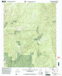
2002 Map of Honey Boy Ranch
USGS Topo · Published 2003About this map
Honey Boy Ranch and Emerson Ranch anchor this high-altitude landscape within the Santa Fe National Forest, where the topography is defined by a series of high valleys or "valles." The drainage network is complex, featuring Cow Creek and numerous small ritos, such as the Rito de los Manzanares and Rito de los Quemazones, which navigate the deep canyons.
Find a feature on this map
25 named features on this map. Tap any name to fly to it.
Don’t see what you’re looking for? This feature index may not catch every label — zoom into the map to look around manually.
Map Details
Editions of this 2002 Honey Boy Ranch Map
This is the sole edition of this map. No revisions or reprints were ever made.
Other maps of this area

1889 · Las Vegas
USGS Topo · 1:125,000

1889 · Santa Fe
USGS Topo · 1:125,000

1891 · Las Vegas
USGS Topo · 1:125,000

1893 · Las Vegas
USGS Topo · 1:125,000

1894 · Santa Fe
USGS Topo · 1:125,000

1954 · Santa Fe
USGS Topo · 1:250,000

1958 · Santa Fe
USGS Topo · 1:250,000

1961 · San Geronimo
USGS Topo · 1:24,000

1961 · El Porvenir
USGS Topo · 1:24,000

1961 · Honey Boy Ranch
USGS Topo · 1:24,000