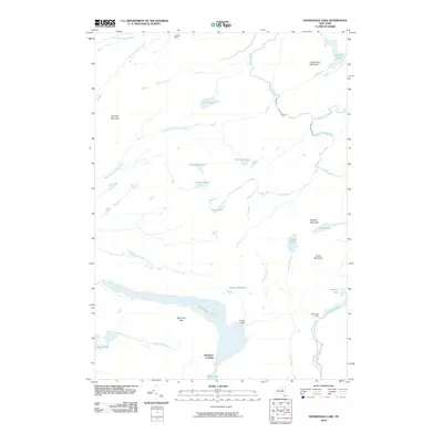
2010 Map of Honnedaga Lake
USGS Topo · Published 2010About this map
Honedaga Lake anchors this portion of the Herkimer County wilderness, surrounded by a complex network of high-elevation water bodies and drainage basins. Remote seasonal outposts like Forest Lodge and Herkimer Landing sit along the lake's southern and eastern shores, reflecting the area's long-standing character as a destination for backwoods sport and timber management. The topography is defined by significant peaks such as Ice Cave Mountain and Panther Mountain, which dictate the paths of numerous waterways, including the North Branch Black River and West Canada Creek. In the northern reaches, Cahans Farm represents a rare point of agricultural naming in a landscape otherwise dominated by intricate brooks and clusters of smaller basins like Snyder Lake and Twin Lakes. The presence of Swanson Dam near First Stillwater indicates localized water control within this densely forested Adirondack environment.
Find a feature on this map
34 named features on this map. Tap any name to fly to it.
Don’t see what you’re looking for? This feature index may not catch every label — zoom into the map to look around manually.
Map Details
Editions of this 2010 Honnedaga Lake Map
This is the sole edition of this map. No revisions or reprints were ever made.
Other maps of this area

1900 · Canada Lake
USGS Topo · 1:62,500

1900 · Wilmurt
USGS Topo · 1:62,500

1901 · Old Forge
USGS Topo · 1:62,500

1902 · Wilmurt
USGS Topo · 1:62,500

1903 · West Canada Lakes
USGS Topo · 1:62,500

1904 · Piseco Lake
USGS Topo · 1:62,500

1906 · Piseco Lake
USGS Topo · 1:62,500

1908 · Piseco Lake
USGS Topo · 1:62,500

1950 · Utica
USGS Topo · 1:250,000
1954 · Ohio
USGS Topo · 1:62,500