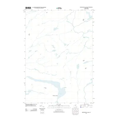
2013 Map of Honnedaga Lake
USGS Topo · Published 2013About this map
Honnedaga Lake and the surrounding wilderness of Herkimer County dominate this 2013 landscape, where human settlement is confined to isolated outposts like Forest Lodge and Herkimer Landing. The terrain is defined by a dense network of high-elevation water bodies and drainage systems, including the Middle Br Black River and West Canada Cr. Small, remote lakes such as Monument Lake, Gooseneck Lake, and the Twin Lakes are scattered across the quadrangle, connected by various brooks and seasonal flows like Elbow Brook and Yale Brook. The elevation rises toward distinct peaks including Panther Mtn and Ice Cave Mtn, while Cahans Farm in the north suggests the limited agricultural reach in this heavily forested environment. This map captures a preserved pocket of the Adirondacks characterized by its intricate hydrology and varied topography, from the Raymond Hills to the marshy Stearns Mudhole.
Find a feature on this map
34 named features on this map. Tap any name to fly to it.
Don’t see what you’re looking for? This feature index may not catch every label — zoom into the map to look around manually.
Map Details
Editions of this 2013 Honnedaga Lake Map
This is the sole edition of this map. No revisions or reprints were ever made.
Other maps of this area

1900 · Canada Lake
USGS Topo · 1:62,500

1900 · Wilmurt
USGS Topo · 1:62,500

1901 · Old Forge
USGS Topo · 1:62,500

1902 · Wilmurt
USGS Topo · 1:62,500

1903 · West Canada Lakes
USGS Topo · 1:62,500

1904 · Piseco Lake
USGS Topo · 1:62,500

1906 · Piseco Lake
USGS Topo · 1:62,500

1908 · Piseco Lake
USGS Topo · 1:62,500

1950 · Utica
USGS Topo · 1:250,000
1954 · Ohio
USGS Topo · 1:62,500