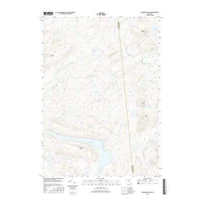
2016 Map of Honnedaga Lake
USGS Topo · Published 2016About this map
Honnedaga Lake dominates the southern portion of this high-elevation Adirondack landscape, where the border between Hamilton Co and Herkimer Co bisects a densely concentrated system of lakes and mountain peaks. The map reveals an intricate drainage network defined by the N Br Black River and the Middle Br Black River, which carve through the Raymond Hills. Higher elevations are marked by prominent summits such as Ice Cave Mtn and Panther Mtn, illustrating the complex topography of the West Canada Lakes Wilderness area. The distribution of small water bodies like Gooseneck Lake, Snyder Lake, and the Twin Lakes suggests a terrain shaped by glacial activity, where high-altitude ponds are connected by seasonal brooks like Natural Hatchery Brook and Elbow Brook.
Find a feature on this map
31 named features on this map. Tap any name to fly to it.
Don’t see what you’re looking for? This feature index may not catch every label — zoom into the map to look around manually.
Map Details
Editions of this 2016 Honnedaga Lake Map
This is the sole edition of this map. No revisions or reprints were ever made.
Other maps of this area

1900 · Canada Lake
USGS Topo · 1:62,500

1900 · Wilmurt
USGS Topo · 1:62,500

1901 · Old Forge
USGS Topo · 1:62,500

1902 · Wilmurt
USGS Topo · 1:62,500

1903 · West Canada Lakes
USGS Topo · 1:62,500

1904 · Piseco Lake
USGS Topo · 1:62,500

1906 · Piseco Lake
USGS Topo · 1:62,500

1908 · Piseco Lake
USGS Topo · 1:62,500

1950 · Utica
USGS Topo · 1:250,000
1954 · Ohio
USGS Topo · 1:62,500