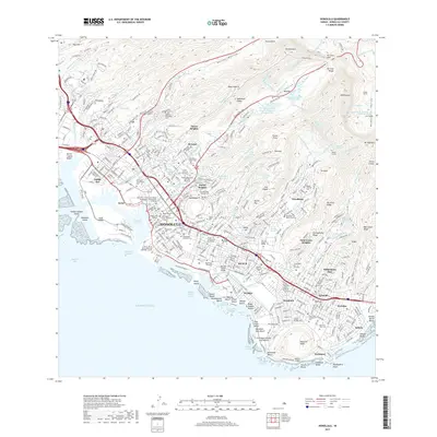
2017 Map of Honolulu
USGS Topo · Published 2017About this map
Punchbowl and the steep residential ridges of Pacific Heights and Saint Louis Heights dominate the backdrop of this 2017 survey of the Hawaiian capital. The map captures the dense urban corridor stretching from Kalihi Kai through Iwilei and the downtown waterfront at Honolulu Harbor, reaching southeast to Waikīkī and Diamond Head Memorial Park Cem. This modern record is particularly valuable for its detailed indexing of the city's complex cultural landscape, including numerous ethnically specific burial grounds such as the Moiliili Japanese Cem, Yee King Tong Chinese Cem, and the Kaulilani Portuguese Cem. Inland, the terrain rises sharply into the Ko'olau Range, where the Nu'uanu Reservoir Number Four sits below the famous Nu'uanu Pali lookout, illustrating the dramatic geography that constrains and defines the city's growth within its volcanic valleys.
Find a feature on this map
110 named features on this map. Tap any name to fly to it.
Don’t see what you’re looking for? This feature index may not catch every label — zoom into the map to look around manually.
Map Details
Editions of this 2017 Honolulu Map
This is the sole edition of this map. No revisions or reprints were ever made.
Other maps of this area

1952 · Koko Head
USGS Topo · 1:24,000

1952 · Mokapu
USGS Topo · 1:24,000

1953 · Honolulu
USGS Topo · 1:24,000

1953 · Puuloa
USGS Topo · 1:24,000

1954 · Oahu
USGS Topo · 1:250,000

1954 · Kaneohe
USGS Topo · 1:24,000

1954 · Waipahu
USGS Topo · 1:24,000

1959 · Mokapu
USGS Topo · 1:24,000

1959 · Koko Head
USGS Topo · 1:24,000

1959 · Kaneohe
USGS Topo · 1:24,000