
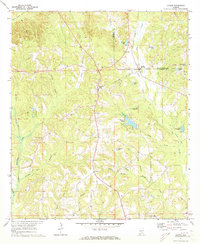
1971 Map of Honoraville
USGS Topo · Published 1973About this map
Honoraville and its surrounding countryside in the early 1970s appear as a landscape of rural congregations and active land modification. The area is heavily marked by Strip Mines, particularly along the western reaches of Pigeon Creek and near the settlement of Midway. These excavations create a distinct visual contrast against the natural drainage patterns of Graydon Branch and Skipper Mill Branch.
Find a feature on this map
41 named features on this map. Tap any name to fly to it.
Don’t see what you’re looking for? This feature index may not catch every label — zoom into the map to look around manually.
Map Details
Editions of this 1971 Honoraville Map
This is the sole edition of this map. No revisions or reprints were ever made.
Other maps of this area

1953 · Andalusia
USGS Topo · 1:250,000

1957 · Andalusia
USGS Topo · 1:250,000

1971 · Luverne
USGS Topo · 1:24,000

1971 · Fullers Crossroads
USGS Topo · 1:24,000

1971 · Pigeon Creek
USGS Topo · 1:24,000

1971 · Fort Deposit
USGS Topo · 1:24,000

1971 · Moodys Crossroads
USGS Topo · 1:24,000

1971 · Greenville East
USGS Topo · 1:24,000

1971 · Danielsville
USGS Topo · 1:24,000
1971 · Lapine
USGS Topo · 1:24,000