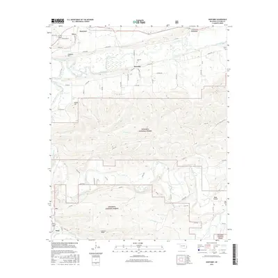
2016 Map of Hontubby
USGS Topo · Published 2016About this map
Heavener and the valley of the Poteau River anchor this 2016 survey of LeFlore County, where the plains of eastern Oklahoma meeting the rising foothills of the Ouachita National Forest. The map documents a landscape defined by sharp topographical contrasts, ranging from the prominent ridge of Walker Mtn to the secluded Hontubby Falls on Hontubby Cr. Small, enduring settlements like Hontubby, Haw Creek, and Forrester are scattered along a network of county roads, providing critical reference points for local history. Several family-named cemeteries, including the Hontubby Cem and Loving Cem, offer valuable data for genealogists tracking generations within the timber and agricultural communities of this region. To the south, the terrain becomes increasingly complex across the Shawnee Ridges, illustrating the transition into the protected forest lands near Stapp and Zoe.
Find a feature on this map
63 named features on this map. Tap any name to fly to it.
Don’t see what you’re looking for? This feature index may not catch every label — zoom into the map to look around manually.
Map Details
Editions of this 2016 Hontubby Map
This is the sole edition of this map. No revisions or reprints were ever made.
Other maps of this area

1887 · Poteau Mountain #2
USGS Topo · 1:62,500

1890 · Poteau Mountain
USGS Topo · 1:125,000

1899 · Poteau Mountain
USGS Topo · 1:125,000

1900 · Winding Stair
USGS Topo · 1:125,000

1909 · Winding Stair
USGS Topo · 1:125,000

1950 · Mcalester
USGS Topo · 1:250,000
1958 · Loving
USGS Topo · 1:24,000
1958 · Bates
USGS Topo · 1:62,500

1958 · Potter
USGS Topo · 1:62,500
1958 · Bates
USGS Topo · 1:24,000