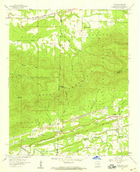
1958 Map of Bates
USGS Topo · Published 1959About this map
The Oklahoma Arkansas state line bisects this 1958 survey, where the coal and timber industries of the Ouachita National Forest define the regional economy. Settlements such as Bates, Coaldale, and Weeks are scattered along the base of the massive Poteau Mountain, connected by the Kansas City Southern and Chicago Rock Island and Pacific railroads. Heavy industrial activity is evident through the numerous mines and tailings piles lining the valley floor near Sugar Creek. Local life centers around rural landmarks like Cedarville Ch and West Harmony Ch, while historical river crossings such as Trestle Ford and Black Ford provide a look at the early transportation network along the Poteau River.
Find a feature on this map
40 named features on this map. Tap any name to fly to it.
Don’t see what you’re looking for? This feature index may not catch every label — zoom into the map to look around manually.
Map Details
Editions of this 1958 Bates Map
3 editions found
Other maps of this area

1887 · Poteau Mountain #2
USGS Topo · 1:62,500

1887 · Greenwood
USGS Topo · 1:62,500

1890 · Fort Smith
USGS Topo · 1:125,000

1890 · Poteau Mountain
USGS Topo · 1:125,000

1899 · Poteau Mountain
USGS Topo · 1:125,000

1900 · Sallisaw
USGS Topo · 1:125,000

1900 · Winding Stair
USGS Topo · 1:125,000

1909 · Winding Stair
USGS Topo · 1:125,000

1911 · Sallisaw
USGS Topo · 1:125,000

1943 · Fort Smith
USGS Topo · 1:125,000