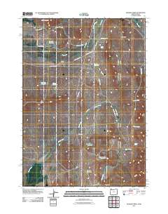
2011 Map of Hooker Creek
USGS Topo · Published 2011About this map
Hooker Creek and its many seasonal water management features dominate this high-desert ranching landscape in southeastern Oregon. The 2011 survey reveals an intricate network of local irrigation and livestock water sources, including Last Change Reservoir, Hooker Reservoir, and Stearns Reservoir. Human activity is centered around established family operations like Carter Ranch and E Jones Ranch, connected by a web of remote desert roads such as Silver City Cutoff Rd and Old Hwy 95 S.
Find a feature on this map
34 named features on this map. Tap any name to fly to it.
Don’t see what you’re looking for? This feature index may not catch every label — zoom into the map to look around manually.
Map Details
Editions of this 2011 Hooker Creek Map
This is the sole edition of this map. No revisions or reprints were ever made.
Other maps of this area

1892 · Silver City
USGS Topo · 1:125,000

1894 · Silver City
USGS Topo · 1:125,000

1898 · Silver City
USGS Topo · 1:125,000

1955 · Jordan Valley
USGS Topo · 1:250,000

1955 · Boise
USGS Topo · 1:250,000

1957 · Jordan Valley
USGS Topo · 1:250,000

1958 · Boise
USGS Topo · 1:250,000

1958 · Jordan Valley
USGS Topo · 1:250,000

1962 · Boise
USGS Topo · 1:250,000

1965 · Rooster Comb Peak
USGS Topo · 1:62,500