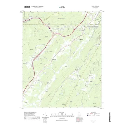
2020 Map of Hooker
USGS Topo · Published 2020About this map
Lookout Mountain dominates this landscape where the Tennessee and Georgia borders meet, forming a high plateau that historically dictated movement through the region. The map captures the complex terrain of the southern Appalachian ridges, defined by the winding course of Lookout Creek and the deep incisions of Slygo Valley and Richmond Gulf. Evidence of the area's deep-rooted history is visible in the numerous family burial grounds and small community landmarks, such as Paynes Chapel Cem, Deakins Cem, and Bethlehem Cem. Significant portions of the northeast are preserved within the Chickamauga and Chattanooga National Military Park, highlighting the strategic importance of this corridor. From the industrial valley settlements of New England and Morganville to the recreational and aviation hub at Lookout Mountain Airport, the map illustrates a modern geography built atop an intricate network of gaps and hollows.
Find a feature on this map
184 named features on this map. Tap any name to fly to it.
Don’t see what you’re looking for? This feature index may not catch every label — zoom into the map to look around manually.
Map Details
Editions of this 2020 Hooker Map
This is the sole edition of this map. No revisions or reprints were ever made.
Other maps of this area

1886 · Ringgold
USGS Topo · 1:125,000

1886 · Stevenson
USGS Topo · 1:125,000

1888 · Chattanooga
USGS Topo · 1:125,000

1892 · Ringgold
USGS Topo · 1:125,000

1892 · Stevenson
USGS Topo · 1:125,000

1893 · Chattanooga
USGS Topo · 1:125,000

1895 · Stevenson
USGS Topo · 1:125,000

1895 · Sewanee
USGS Topo · 1:125,000

1935 · Durham
USGS Topo · 1:24,000

1936 · Trenton
USGS Topo · 1:24,000