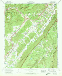
1970 Map of Hooker
USGS Topo · Published 1972About this map
Lookout Mountain and Slygo Ridge dominate this 1970 landscape, where the borders of Tennessee and Georgia meet along the dramatic relief of the Cumberland Plateau. This survey, mapped by the Tennessee Valley Authority, captures the corridor where Interstate 24 and the Louisville and Nashville railroad cut through the gaps of Raccoon Mountain. The map provides significant genealogical value through its many small family cemeteries, including Deakins Cem and Haswell Cem, alongside landmarks like Wildwood Chapel and the North Dade Sch. The rugged eastern slope of the quadrangle is defined by the Chickamauga and Chattanooga National Military Park, while industrial activity is noted at several Quarry and Gravel Pit sites near Morganville. Settlement patterns follow the valleys of Lookout Creek and Slygo Creek, reflecting the rural character of Dade and Walker counties at the start of the 1970s.
Find a feature on this map
89 named features on this map. Tap any name to fly to it.
Don’t see what you’re looking for? This feature index may not catch every label — zoom into the map to look around manually.
Map Details
Editions of this 1970 Hooker Map
This is the sole edition of this map. No revisions or reprints were ever made.
Other maps of this area

1886 · Ringgold
USGS Topo · 1:125,000

1886 · Stevenson
USGS Topo · 1:125,000

1888 · Chattanooga
USGS Topo · 1:125,000

1892 · Ringgold
USGS Topo · 1:125,000

1892 · Stevenson
USGS Topo · 1:125,000

1893 · Chattanooga
USGS Topo · 1:125,000

1895 · Stevenson
USGS Topo · 1:125,000

1895 · Sewanee
USGS Topo · 1:125,000

1935 · Durham
USGS Topo · 1:24,000

1936 · Trenton
USGS Topo · 1:24,000