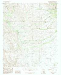
1985 Map of Hookers Hot Springs
USGS Topo · Published 1985About this map
Hookers Hot Springs serves as the focal point of this arid landscape within the Coronado National Forest during the mid-1980s. Tucked into the foothills of the Winchester Mountains, the map reveals a rugged terrain defined by a network of seasonal water sources and deep incisions including Hot Springs Canyon and Carruthers (Redrock) Canyon. The geography reflects the ranching and resource-management heritage of Cochise County, where isolated water features like N O Spring, V F Springs, and Riggs Seep were essential for survival.
Find a feature on this map
21 named features on this map. Tap any name to fly to it.
Don’t see what you’re looking for? This feature index may not catch every label — zoom into the map to look around manually.
Map Details
Editions of this 1985 Hookers Hot Springs Map
2 editions found
Other maps of this area

1943 · Dragoon
USGS Topo · 1:62,500

1943 · Winchester Mts.
USGS Topo · 1:62,500

1945 · Redington
USGS Topo · 1:62,500

1945 · Winchester Mts.
USGS Topo · 1:62,500

1945 · Happy Valley
USGS Topo · 1:62,500

1956 · Tucson
USGS Topo · 1:250,000

1957 · Redington
USGS Topo · 1:62,500

1957 · Winchester Mts.
USGS Topo · 1:62,500

1958 · Tucson
USGS Topo · 1:250,000

1958 · Happy Valley
USGS Topo · 1:62,500