Loading...
Loading map...1964 Map of Hooper Bay
USGS Topo · Published 1964About this map
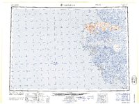
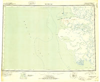
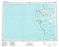
The coastal village of Hooper Bay and the surrounding Yukon-Kuskokwim Delta are shown in detail during the early 1960s. This survey illustrates a landscape dominated by the complex hydrology of the Kashunuk River and Kun River systems, which wind through expansive wetlands and tidal flats. The Askinuk Mountains provide a dramatic topographic break from the low-lying marshes, rising to peaks like Towak Mountain and Scammon Bay Castle Hill near the shores of the Bering Sea.
Find a feature on this map
43 named features on this map. Tap any name to fly to it.
Don’t see what you’re looking for? This feature index may not catch every label — zoom into the map to look around manually.
Map Details
Date Portrayed1964
Date Published1964
PublisherU.S. Geological Survey
Map TypeTopographic
Scale1:250,000
Physical Dimensions30.69 x 22.94 inches
Editions of this 1964 Hooper Bay Map
This is the sole edition of this map. No revisions or reprints were ever made.
Historical Maps of Hooper Bay Through Time
3 maps found
Featured Locations
Source Details
SourceU.S. Geological Survey
CopyrightPublic Domain