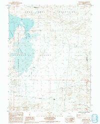
1985 Map of Hooten Well
USGS Topo · Published 1993About this map
The arid Basin and Range landscape of Lyon and Churchill counties is defined here by the convergence of early western transit routes and modern water management. The west is dominated by the Lahonton State Reservoir, part of the Lahonton State Recreation Area, featuring Carp Dam and a measured spillway elevation of 1267.4 feet as of 1980. This industrial-scale hydration contrasts sharply with the nearby Alkali Flat and the barren slopes of the Dead Camel Mountains.
Find a feature on this map
18 named features on this map. Tap any name to fly to it.
Don’t see what you’re looking for? This feature index may not catch every label — zoom into the map to look around manually.
Map Details
Editions of this 1985 Hooten Well Map
2 editions found
Other maps of this area

1891 · Wabuska
USGS Topo · 1:125,000

1894 · Wabuska
USGS Topo · 1:125,000

1908 · Carson Sink
USGS Topo · 1:250,000

1910 · Carson Sink
USGS Topo · 1:250,000

1951 · Weber Reservoir
USGS Topo · 1:62,500

1951 · Fallon
USGS Topo · 1:62,500

1957 · Wabuska
USGS Topo · 1:62,500

1957 · Silver Springs
USGS Topo · 1:62,500

1957 · Reno
USGS Topo · 1:250,000

1959 · Reno
USGS Topo · 1:250,000