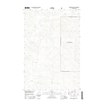
2014 Map of Hootowl Creek East
USGS Topo · Published 2014About this map
Little Missouri National Grassland dominates the eastern half of this North Dakota landscape, where the broken terrain is defined by a dense network of intermittent drainage channels. The map captures a section of Golden Valley County characterized by the winding paths of Beaver Cr and Hootowl Cr as they navigate the deeply eroded badlands topography. Local ranching access is evidenced by the sparse grid of rural routes, including Tescher Rd and Mosher Rd, which traverse the high ground between creek beds. The drainage patterns of Elk Cr and Alkali Cr reflect the complex hydrology of the Missouri River watershed in this part of the Western Great Plains. This 2014 survey provides a detailed look at land management and natural features within the national grassland boundary, serving as a point of reference for those studying the geography of the Little Missouri basin.
Find a feature on this map
10 named features on this map. Tap any name to fly to it.
Don’t see what you’re looking for? This feature index may not catch every label — zoom into the map to look around manually.
Map Details
Editions of this 2014 Hootowl Creek East Map
This is the sole edition of this map. No revisions or reprints were ever made.
Other maps of this area

1953 · Watford City
USGS Topo · 1:250,000

1957 · Watford City
USGS Topo · 1:250,000

1967 · Watford City
USGS Topo · 1:250,000

1970 · Eagle Draw
USGS Topo · 1:24,000

1974 · Hootowl Creek West
USGS Topo · 1:24,000

1974 · Trotters SE
USGS Topo · 1:24,000

1974 · West Twin Butte
USGS Topo · 1:24,000

1974 · Trotters
USGS Topo · 1:24,000

1974 · Roosevelt Creek West
USGS Topo · 1:24,000
1974 · Hootowl Creek SW
USGS Topo · 1:24,000