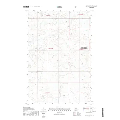
2020 Map of Hootowl Creek East
USGS Topo · Published 2020About this map
The Little Missouri National Grassland dominates the eastern portion of this Golden Valley County landscape, illustrating the conservation of North Dakota's shortgrass prairie. The terrain is defined by a dense network of seasonal drainages, including the eponymous Hootowl Cr and the larger Beaver Cr system. These waterways cut through the topography, creating a complex series of draws and ridges characteristic of the badlands region. Human presence is marked primarily by rural transit routes like Tescher Rd, Mosher Rd, and Elk Creek Rd, which follow the natural contours of the land and sections of the Public Land Survey System. This survey provides a precise view of the hydrography in the northwestern corner of the state, tracing the paths of Horse Cr, Bell Lake Cr, and Elk Cr as they shape the open range.
Find a feature on this map
15 named features on this map. Tap any name to fly to it.
Don’t see what you’re looking for? This feature index may not catch every label — zoom into the map to look around manually.
Map Details
Editions of this 2020 Hootowl Creek East Map
This is the sole edition of this map. No revisions or reprints were ever made.
Other maps of this area

1953 · Watford City
USGS Topo · 1:250,000

1957 · Watford City
USGS Topo · 1:250,000

1967 · Watford City
USGS Topo · 1:250,000

1970 · Eagle Draw
USGS Topo · 1:24,000

1974 · Hootowl Creek West
USGS Topo · 1:24,000

1974 · Trotters SE
USGS Topo · 1:24,000

1974 · West Twin Butte
USGS Topo · 1:24,000

1974 · Trotters
USGS Topo · 1:24,000

1974 · Roosevelt Creek West
USGS Topo · 1:24,000
1974 · Hootowl Creek SW
USGS Topo · 1:24,000