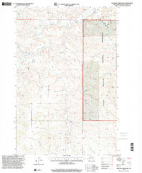
1997 Map of Hootowl Creek East
USGS Topo · Published 2001About this map
The Little Missouri National Grassland dominates the eastern portion of this landscape in North Dakota’s Golden Valley County, where the terrain is carved by an intricate network of drainages. The Sixteenth Guide Meridian West serves as a prominent north-south boundary through the center of the sheet, separating the public grassland from mixed-use lands to the west. Waterways define the local geography, with the namesake Hootowl Creek joining with Beaver Creek, Horse Creek, and Elk Creek as they wind through the high prairie. Aside from a small Gravel Pit and some light-duty roads, the map shows a sparsely populated area focused on ranching and natural resource management, punctuated only by occasional landmarks like Bell Lake and Alkali Creek.
Find a feature on this map
11 named features on this map. Tap any name to fly to it.
Don’t see what you’re looking for? This feature index may not catch every label — zoom into the map to look around manually.
Map Details
Editions of this 1997 Hootowl Creek East Map
This is the sole edition of this map. No revisions or reprints were ever made.
Other maps of this area

1953 · Watford City
USGS Topo · 1:250,000

1957 · Watford City
USGS Topo · 1:250,000

1967 · Watford City
USGS Topo · 1:250,000

1970 · Eagle Draw
USGS Topo · 1:24,000

1974 · Hootowl Creek West
USGS Topo · 1:24,000

1974 · Trotters SE
USGS Topo · 1:24,000

1974 · West Twin Butte
USGS Topo · 1:24,000

1974 · Trotters
USGS Topo · 1:24,000

1974 · Roosevelt Creek West
USGS Topo · 1:24,000
1974 · Hootowl Creek SW
USGS Topo · 1:24,000