
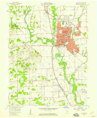
1947 Map of Hope
USGS Topo · Published 1966About this map
Flatrock River defines the northwestern corner of this territory, where the Pennsylvania railroad line crosses the water near Flat Rock. The landscape is a well-settled agricultural plain in the late 1940s, marked by a dense network of small communities and family-named cemeteries. The town of Hope serves as the primary hub in the east, characterized by its grid of streets and the prominent Moravian Cem. To the south and west, the smaller settlements of Clifford and St Louis Crossing sit along the rail lines that facilitated the region's mid-century rural economy.
Find a feature on this map
40 named features on this map. Tap any name to fly to it.
Don’t see what you’re looking for? This feature index may not catch every label — zoom into the map to look around manually.
Map Details
Editions of this 1947 Hope Map
This is the sole edition of this map. No revisions or reprints were ever made.
Other maps of this area

1942 · Columbus
USGS Topo · 1:125,000

1948 · Edinburg
USGS Topo · 1:24,000

1948 · Hope
USGS Topo · 1:24,000

1948 · Lewis Creek
USGS Topo · 1:24,000

1948 · Marietta
USGS Topo · 1:24,000

1950 · Edinburg
USGS Topo · 1:62,500

1953 · Cincinnati
USGS Topo · 1:250,000

1956 · Waldron
USGS Topo · 1:24,000

1957 · Cincinnati
USGS Topo · 1:250,000
1958 · Columbus
USGS Topo · 1:24,000