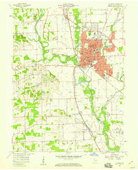
1958 Map of Columbus
USGS Topo · Published 1959About this map
The confluence of the Flatrock River and Driftwood River forms the East Fork White River at Columbus, creating a complex waterway system that defined the city's early development. This late-1950s survey captures the city at a moment of significant institutional growth, as evidenced by the dense cluster of educational and civic landmarks including St Bartholomews Sch, Jr High Sch, and the Court House. To the north, Bakalar Air Force Base marks the era's military footprint, while the Pennsylvania railroad line bisects the landscape, connecting the industrial center to surrounding hamlets like Walesboro and Garden City. The map preserves the locations of numerous neighborhood schools such as McKinley Sch and Garfield Sch, alongside rural landmarks like the Covered Bridge on Clifty Creek.
Find a feature on this map
57 named features on this map. Tap any name to fly to it.
Don’t see what you’re looking for? This feature index may not catch every label — zoom into the map to look around manually.
Map Details
Editions of this 1958 Columbus Map
This is the sole edition of this map. No revisions or reprints were ever made.
Other maps of this area

1942 · Franklin
USGS Topo · 1:125,000

1942 · Columbus
USGS Topo · 1:125,000

1947 · Franklin
USGS Topo · 1:62,500

1947 · Hope
USGS Topo · 1:24,000

1948 · Edinburg
USGS Topo · 1:24,000

1948 · New Bellsville
USGS Topo · 1:24,000

1948 · Hope
USGS Topo · 1:24,000

1948 · Waymansville
USGS Topo · 1:24,000

1948 · Nineveh
USGS Topo · 1:24,000

1950 · Franklin
USGS Topo · 1:62,500