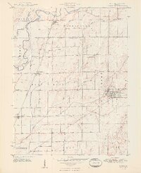
1948 Map of Hope
USGS Topo · Published 1948About this map
Hope serves as the primary hub of this 1940s agricultural landscape, where the Pennsylvania railroad and Haw Creek intersect to support the local economy. The area is dense with early burial grounds and small communities, showing a settled pattern of family farmsteads and rural parishes. To the northwest, the Flatrock Creek winds through Jackson and German townships, passing near Willow Park and the small settlement of Flat Rock. Genealogists will find significant value in the distribution of family and denominational landmarks, including the Moravian Cem and Roberts Chapel Cem. Further south, the distinction between St Louis Crossing and Old St Louis reveals the shifting centers of community life as road and rail networks evolved, while smaller hamlets like Trimnell and Clifford anchor the surrounding townships of Flat Rock and Haw Creek.
Find a feature on this map
42 named features on this map. Tap any name to fly to it.
Don’t see what you’re looking for? This feature index may not catch every label — zoom into the map to look around manually.
Map Details
Editions of this 1948 Hope Map
2 editions found
Other maps of this area

1942 · Columbus
USGS Topo · 1:125,000

1947 · Hope
USGS Topo · 1:24,000

1948 · Edinburg
USGS Topo · 1:24,000

1948 · Hope
USGS Topo · 1:24,000

1948 · Lewis Creek
USGS Topo · 1:24,000

1948 · Marietta
USGS Topo · 1:24,000

1950 · Edinburg
USGS Topo · 1:62,500

1953 · Cincinnati
USGS Topo · 1:250,000

1956 · Waldron
USGS Topo · 1:24,000

1957 · Cincinnati
USGS Topo · 1:250,000