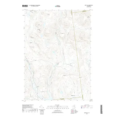
2019 Map of Hope Falls
USGS Topo · Published 2019About this map
East Stony Creek and its many tributaries carve through a complex upland terrain where the borders of Fulton, Hamilton, Saratoga, and Warren counties meet. The small settlement of Hope Falls serves as a local landmark along the creek, connected to the southern reaches by Hope Falls Rd. To the southwest, the Sacandaga River defines the valley floor, flanked by family-history sites such as the Wadsworth Cem and Willard Cem. The landscape is dominated by named peaks including Huckleberry Mtn, Scribner Mtn, and Buck Mtn, while the southern edge transition into the waters of the Northville Reservoir near Maple Grove. This modern survey documents the established network of mountain roads, like Tannery Rd and Old Northville Rd, that provide access to remote water bodies like Bennett Lake and Greenfield Lake.
Find a feature on this map
54 named features on this map. Tap any name to fly to it.
Don’t see what you’re looking for? This feature index may not catch every label — zoom into the map to look around manually.
Map Details
Editions of this 2019 Hope Falls Map
This is the sole edition of this map. No revisions or reprints were ever made.
Other maps of this area

1899 · Broadalbin
USGS Topo · 1:62,500

1902 · Broadalbin
USGS Topo · 1:62,500

1903 · Gloversville
USGS Topo · 1:62,500

1907 · Lake Pleasant
USGS Topo · 1:62,500

1910 · Stony Creek
USGS Topo · 1:62,500

1943 · Gloversville
USGS Topo · 1:62,500

1945 · Edinburg
USGS Topo · 1:24,000

1945 · Northville
USGS Topo · 1:24,000
1945 · Jackson Summit
USGS Topo · 1:24,000
1946 · Edinburg
USGS Topo · 1:24,000