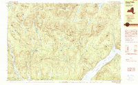
1990 Map of Hope Falls
USGS Topo · Published 1990About this map
East Stony Creek carves a central path through this section of the Adirondack Park, where the transition from high mountain peaks to the waters of the Great Sacandaga Lake defines the landscape. Small settlements such as Hope Falls and Tennantville are scattered along the narrow valley floors, while the eastern edge of the map shows the shoreline of the lake near West Day and Day Center. The terrain is dominated by named peaks like Spruce Mountain and Gene Edwards Mountain, reflecting the area's geological character.
Find a feature on this map
68 named features on this map. Tap any name to fly to it.
Don’t see what you’re looking for? This feature index may not catch every label — zoom into the map to look around manually.
Map Details
Editions of this 1990 Hope Falls Map
This is the sole edition of this map. No revisions or reprints were ever made.
Other maps of this area

1899 · Broadalbin
USGS Topo · 1:62,500

1902 · Broadalbin
USGS Topo · 1:62,500

1902 · Saratoga
USGS Topo · 1:62,500

1903 · Luzerne
USGS Topo · 1:62,500

1903 · Gloversville
USGS Topo · 1:62,500

1907 · Lake Pleasant
USGS Topo · 1:62,500

1910 · Stony Creek
USGS Topo · 1:62,500

1942 · Saratoga
USGS Topo · 1:62,500

1943 · Gloversville
USGS Topo · 1:62,500

1945 · Edinburg
USGS Topo · 1:24,000