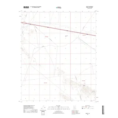
2018 Map of Hope SE
USGS Topo · Published 2018About this map
The Harquahala Plain serves as the central landscape of this western Arizona survey, dominated by the massive infrastructure of the Central Arizona Project Aqueduct. This modern water-delivery system carves a distinct path across the desert floor, reflecting the critical role of engineering in the arid Southwest. To the southeast, the terrain rises sharply into the Eagletail Mountains, a prominent landform featuring the Natural Arch. The area's transportation network is defined by a series of specialized desert routes and utility access paths, such as At&T Frontage Rd and the curiously named Sore Finger Rd. While largely unpopulated, the map documents the meticulous township and range divisions, including t3n r13w and t2n r12w, which organize this expanse of La Paz County. Other local thoroughfares like Vinegarroon Rd and Palomas Harquahala Rd provide access through this stark, high-desert environment.
Find a feature on this map
16 named features on this map. Tap any name to fly to it.
Don’t see what you’re looking for? This feature index may not catch every label — zoom into the map to look around manually.
Map Details
Editions of this 2018 Hope SE Map
This is the sole edition of this map. No revisions or reprints were ever made.
Other maps of this area

1942 · Vicksburg
USGS Topo · 1:250,000

1954 · Phoenix
USGS Topo · 1:250,000

1957 · Phoenix
USGS Topo · 1:250,000

1958 · Phoenix
USGS Topo · 1:250,000

1960 · Phoenix
USGS Topo · 1:250,000

1961 · Hope
USGS Topo · 1:62,500

1961 · Lone Mountain
USGS Topo · 1:62,500

1962 · Little Horn Mts
USGS Topo · 1:62,500

1962 · Eagletail Mts
USGS Topo · 1:62,500

1969 · Phoenix
USGS Topo · 1:250,000